Subscriptions / Plans
Chart Subscriptions
Nautical charts called "TZ Maps" can be purchased on TZ iBoat by tapping on the “TZ” button located at the top left of your screen and selecting “Store” and then "TZ MAPS".
Each TZ Map area includes Vector charts (or electronic chart) and Raster charts (digital copy of paper charts) on selected areas. Note that chart purchase is a one-year subscription that automatically starts with a 7-day trial allowing you to evaluate the data. After one year, the subscription will be renewed automatically unless auto-renew is turned off at least 24 hours before the end of the current period. Charts are continuously updated during the subscription period.
If you decide to not renew the subscription, you will not be able to download or update the chart anymore (after the subscription period ends). Downloaded charts will remain usable on your device with the latest update done during subscription period, but if you reset your device or want to use a new device, you will have to renew your subscription to be able to download the charts again.
Plans
You can subscribe to a plan for TZ iBoat by tapping on the “TZ” button located at the top left of your screen, the selecting “Store” and then "Plans".
TZ iBoat offers four plans. One plan is included free with the application, while three others are available as paid subscriptions.
The paid plans are incremental, meaning each plan includes the features of the previous one. The Essential plan is the entry-level offering, the Premium plan includes all the features of the Essential plan, and the Sport Fishing plan includes all the features of the Premium plan.
Subscriptions are available on a monthly or yearly basis.
This allows you to choose a plan that best fits your needs, with the option to access additional features by upgrading to a higher tier.
Subscription automatically renews unless auto-renew is turned off at least 24 hours before the end of the current period. Account will be charged for renewal within 24 hours prior to the end of the current period at the rate of the selected subscription renewal. Subscriptions and auto-renewal may be managed by going to Account Settings after purchase. Any unused portion of a free trial period, if offered, will be forfeited when purchasing a subscription.
Essential
The Essential plan allow you to connect your onboard instruments and acces live AIS data.
External instrument connection: Add support for onboard instruments and NMEA0183 gateways over Wi-Fi (TCP/UDP). Built-in GPS, Bluetooth, and external GPS receivers remain supported on compatible devices.
AIS: With the AIS feature, you can display AIS targets in TZ iBoat. The new TZ Online AIS feature lets you access AIS targets worldwide via the internet, even without an onboard receiver. If you have an AIS receiver on your boat, TZ iBoat can also display real-time AIS targets over Wi-Fi (NMEA 0183 compatible) and share them with the community.
Auto Pilot: When a route is activated, TZ iBoat automatically sends navigation data to your autopilot via a Wi-Fi NMEA (TCP) connection. Heading to the active waypoint, real-time corrections, precise and secure steering.
Premium
The Premium plan unlocks the following features (Premium Weather, Rain Radar, Marine Bulletins):
Premium Weather: You are currently navigating using GFS weather forecasts. Access exclusive features and 5 additional high-resolution models to plan your trips safely with the most complete and accurate data!
The premium weather service provides access to five higher resolution models (Arpege / Arome / DWD ICON: Global and Europe / NAM CONUS / Copernicus ):
- The Arpege model offers European coverage at a resolution of 10 kilometers and up to 4 days of forecast.
- The Arome model offers coverage of French coasts and bordering countries at a resolution of 1 kilometer and up to 2 days of forecast.
- The NAM CONUS offers coverage for North America at a resolution of 3 kilometers up to 2.5 days of forecast.
- The DWD ICON model offers a :
- Global worldwide coverage at a resolution of 13 kilometers and up to 7.5 days of forecast.
- Europe coverage at a resolution of 6 kilometers and up to 5 days of forecast.
- The Copernicus model offers a Global worldwide resolution at a 9 kilometers resolution up to 10 days of forecast.
Rain Radar: Unlike traditional weather forecasts that rely on models, the Rain Radar provides real observations. This data comes from an extensive network of weather radars covering a large part of the globe. The Rain Radar overlay displays active precipitation areas on your charts, almost anywhere in the world. By activating the animation with a simple click on the "play" button, you can watch the evolution of precipitation over the last three hours. This feature allows you to accurately anticipate precipitation movements, enabling you to know not only if you will be affected by the rain, but also when the skies will begin to clear.
Marine Bulletins (USA Only):
Important: Marine Bulletins are only available in the USA at this time.
Unlike model forecasts, which require personal interpretation, Marine Bulletins deliver expert interpretations directly to you. These bulletins are crafted by seasoned meteorologists from NOAA who analyze weather patterns and identify potential hazards, ensuring that you receive information that is both precise and actionable.
Moreover, Marine Bulletins goes beyond weather predictions: it includes specialized sections for alerts and tropical storms, providing timely warnings that are crucial for planning and response strategies.
With Marine Bulletins, you can navigate with confidence, knowing that you have the most accurate and up-to-date weather information at your disposal, analyzed by professionals to enhance your safety and decision-making on the waters.
Elite
Optimize your fishing trips with advanced oceanographic data seamlessly integrated into TZ iBoat.
The Elite plan Combine the following oceanographic data on your screen:
- Sea Surface Temperature (SST): Identify areas where fish gather based on their thermal comfort. Spot thermal fronts, natural boundaries teeming with marine life.
- Chlorophyll: Visualize phytoplankton zones, the foundation of the food chain. Large predators like tuna are often found here.
- Sea Surface Height (SSH): Locate upwelling zones where nutrients rise from the depths, attracting fish and their prey.
- Ocean Currents: Analyze currents that influence fish movement and plan your trips in optimal conditions.
- Enhanced bathymetry features (with compatible chart coverage): Use detailed underwater structure and depth data to help locate target species.
- Premium Weather: Take full advantage of the "Premium Weather" service included in this subscription. Plan your trips using detailed data on sea state, wind, and temperature. These factors affect fish behavior and determine ideal fishing conditions.
All these data layers can be overlaid, allowing you to easily identify areas where multiple factors converge, maximizing your chances of success!
Comparaison of weather services
| Service | Weather (Free) | Premium Weather (Plan) | Elite (Plan) |
| Wind | 25km | 1km | 1km |
| GFS (0.25° * 0.25°) |
GFS 25km(0.25° * 0.25°) ICON Global 13km(0.125° * 0.125°) ICON Europe 6km(0.062° * 0.062°) Arome 1km(0.01° * 0.01°) Arpege 10km(0.1° * 0.1°) NAM CONUS (0.3° * 0.3°) |
GFS 25km(0.25° * 0.25°) ICON Global 13km(0.125° * 0.125°) ICON Europe 6km(0.062° * 0.062°) Arome 1km(0.01° * 0.01°) Arpege 10km(0.1° * 0.1°) NAM CONUS (0.3° * 0.3°) |
|
| Wind Gust | 25km | 1km | 1km |
| GFS (0.25° * 0.25°) |
GFS 25km(0.25° * 0.25°) ICON Global 13km(0.125° * 0.125°) ICON Europe 6km(0.062° * 0.062°) Arome 1km(0.01° * 0.01°) Arpege 10km(0.1° * 0.1°) NAM CONUS (0.3° * 0.3°) |
GFS 25km(0.25° * 0.25°) ICON Global 13km(0.125° * 0.125°) ICON Europe 6km(0.062° * 0.062°) Arome 1km(0.01° * 0.01°) Arpege 10km(0.1° * 0.1°) NAM CONUS (0.3° * 0.3°) |
|
| Pressure | 50km | 50km | 50km |
| GFS (0.5° * 0.5°) |
GFS 50km(0.5° * 0.5°) ICON Global 50km(0.5° * 0.5°) ICON Europe 50km(0.5° * 0.5°) Arome 50km(0.5° * 0.5°) Arpege 50km(0.5° * 0.5°) NAM CONUS 50km(0.5° * 0.5°) |
GFS 50km(0.5° * 0.5°) ICON Global 50km(0.5° * 0.5°) ICON Europe 50km(0.5° * 0.5°) Arome 50km(0.5° * 0.5°) Arpege 50km(0.5° * 0.5°) NAM CONUS 50km(0.5° * 0.5°) |
|
| Air Temperature | 25km | 1km | 1km |
| GFS (0.25° * 0.25°) |
GFS 25km(0.25° * 0.25°) ICON Global 13km(0.125° * 0.125°) ICON Europe 6km(0.062° * 0.062°) Arome 1km(0.01° * 0.01°) Arpege 10km(0.1° * 0.1°) NAM CONUS (0.3° * 0.3°) |
GFS 25km(0.25° * 0.25°) ICON Global 13km(0.125° * 0.125°) ICON Europe 6km(0.062° * 0.062°) Arome 1km(0.01° * 0.01°) Arpege 10km(0.1° * 0.1°) NAM CONUS (0.3° * 0.3°) |
|
| Cloud | 25km | 1km | 1km |
| GFS (0.25° * 0.25°) |
GFS 25km(0.25° * 0.25°) ICON Global 13km(0.125° * 0.125°) ICON Europe 6km(0.062° * 0.062°) Arome 1km(0.01° * 0.01°) Arpege 10km(0.1° * 0.1°) NAM CONUS (0.3° * 0.3°) |
GFS 25km(0.25° * 0.25°) ICON Global 13km(0.125° * 0.125°) ICON Europe 6km(0.062° * 0.062°) Arome 1km(0.01° * 0.01°) Arpege 10km(0.1° * 0.1°) NAM CONUS (0.3° * 0.3°) |
|
| Precipitation | 25km | 1km | 1km |
| GFS (0.25° * 0.25°) |
GFS 25km(0.25° * 0.25°) ICON Global 13km(0.125° * 0.125°) ICON Europe 6km(0.062° * 0.062°) Arome 1km(0.01° * 0.01°) Arpege 10km(0.1° * 0.1°) NAM CONUS (0.3° * 0.3°) |
GFS 25km(0.25° * 0.25°) ICON Global 13km(0.125° * 0.125°) ICON Europe 6km(0.062° * 0.062°) Arome 1km(0.01° * 0.01°) Arpege 10km(0.1° * 0.1°) NAM CONUS (0.3° * 0.3°) |
|
| Humidity | 25km | 1km | 1km |
| GFS (0.25° * 0.25°) |
GFS 25km(0.25° * 0.25°) ICON Global 13km(0.125° * 0.125°) ICON Europe 6km(0.062° * 0.062°) Arome 1km(0.01° * 0.01°) Arpege 10km(0.1° * 0.1°) NAM CONUS (0.3° * 0.3°) |
GFS 25km(0.25° * 0.25°) ICON Global 13km(0.125° * 0.125°) ICON Europe 6km(0.062° * 0.062°) Arome 1km(0.01° * 0.01°) Arpege 10km(0.1° * 0.1°) NAM CONUS (0.3° * 0.3°) |
|
| Wave (Significant) | 25km | 3km | 3km |
| GFS (0.25° * 0.25°) |
GFS 25km (0.25° * 0.25°) Copernicus Global 9km(0.083° *0.083°) Arome 3km(0.025° * 0.025°) Arpege 10km(0.1° *0.1°) |
GFS 25km (0.25° * 0.25°) Copernicus Global 9km(0.083° *0.083°) Arome 3km(0.025° * 0.025°) Arpege 10km(0.1° *0.1°) |
|
| Current | 8km | 8km | 8km |
| (0.08° *0.08°) | (0.08°*0.08°) | (0.08°*0.08°) | |
| SST - Satellite | - | - | Very High Resolution: 2Km |
| SST - Cloud Free | - | - | Very High Resolution: 1Km |
| Altimetry (SSH) | - | - | High Resolution: 0.08° (8Km) |
| Chlorophyl | - | - | High Resolution: 0.04° (4Km) |
Cancel a Subscription
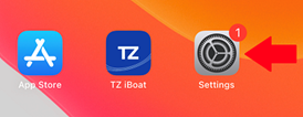
If you need to cancel a subscription (charts or premium weather), you can do so from your device's Settings App. Press the “Home” button and open the Settings App:
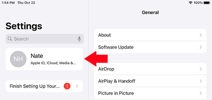
Tap your Apple ID “card” with your name and profile image at the top of the menu:
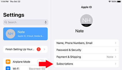
Tap on Subscriptions:
You will see a list of all your active and expired subscriptions. If you want to cancel one, press the desired active subscription and then press Cancel Subscription toward the bottom:
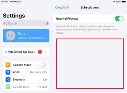
Note that you will still be able to use the service (chart update or premium weather) until the end of the original subscription period.