Marks
TZ iBoat allows for the creation of up to 30,000 marks. Marks are used to plot on the chart specific locations such as fishing spots, hazards, harbors, or preferred anchorages.
To save a mark, tap on the chart at the location you want the mark to be created and select “New Mark” from the Pop-Up menu. A mark will be created with the default icon and color set in the “Marks” settings.
TIP: You can also create a mark by entering its coordinate. Tap on the “TZ” button located on the top left of your screen, select “Add by Lat/Lon” from the Quick Actions and then select “Add Mark by Lat/Lon”. This will display a dedicated Lat/Lon keyboard that will allow you to create the mark using its coordinate.
The mark can be edited from its Pop-Up menu: simply tap on the mark and select the corresponding action from the mark’s Pop-Up menu (color, symbol, delete, …)
To move a mark, simply select “Move” from the Pop-Up menu. A handle will be displayed under the mark allowing you to drag it to a new location:
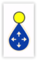
When you are done, tap anywhere to validate.
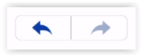
Note that when you edit a mark, the undo/redo icon will appear for a couple of seconds at the top of the screen allowing you to revert to the previous mark state quickly and easily:
All marks can be displayed or hidden on the chart by tapping the “Layer” button located on the bottom right and enabling or disabling the “Marks” button under “User Data”.
TIP: Marks size can be adjusted globally from the Marks setting.
If you need to search for a specific mark or display a list of all your marks, tap on “Smart Search” button on the right of “TZ” button located on the top left of your screen, and select "Mark":
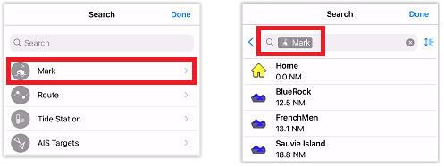
You can search by name and filter the content of the list if you start typing a text. You can also sort the list by name (alphabetical order), range (distance from boat), icon, date (creation date) or color.