Laylines
The "Routing Module" needs to be unlocked to access this feature
Laylines can be displayed on the chart from the Layer button. The Laylines will only be displayed on the chart under the following conditions:
-
Laylines display is enable on the chart
-
True Wind Direction (TWD) is received in TimeZero (note that TimeZero can compute TWD from True Wind Angle and Heading)
-
A Go To or Route is Active and displayed on screen
-
The destination (the active waypoint) is in such a way that the sail boat cannot sail directly to it (sail boat needs to tack).
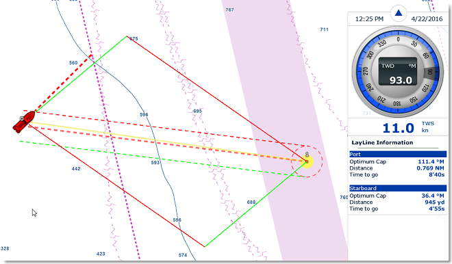
In the example below, the wind direction is coming from the East (displayed using a TWD Gauge NavData). The active waypoint is straight into the wind, and it is not possible for the sail boat to reach the destination directly without tacking. In that case, the Laylines appear on the chart and show the two best tacking points (optimum course and distance):

A Layline NavData can be configured in the NavData bar. This will display the port and starboard optimum course and distance as well as Time to Go (or "Time to Tack").
Note that the laylines computation takes into account the Polar file loaded in the software, true wind direction and currents (tidal and/or oceanic currents).