Premium Weather Service
In addition to the free weather forecasts (based on the GFS model), it is possible to subscribe to a Premium Weather service that adds high resolution and local weather models as well as near real-time rain radar and marine zone forecasts (text bulletins).
Note: The Marine zone forecasts are only available in the USA at this time.
Below is a comparison in between the free weather service and the premium weather service:
| Service | Weather (Free) | Premium Weather (Subscription) |
| Wind | 25Km | 1Km |
| GFS (0.25 * 0.25) | GFS (0.25 * 0.25) ICON Global (0.125 * 0.125) ICON Europe (0.062 * 0.062) Arome (0.01 * 0.01) Arpege (0.1 * 0.1) NAM CONUS (0.3 * 0.3) |
|
| Wind Gust | 25Km | 1Km |
| GFS (0.25 * 0.25) | GFS (0.25 * 0.25) ICON Global (0.125 * 0.125) ICON Europe (0.062 * 0.062) Arome (0.01 * 0.01) Arpege (0.1 * 0.1) NAM CONUS (0.3 * 0.3) |
|
| Pressure | 50Km | 50Km |
| GFS (0.5 * 0.5) | GFS (0.5 * 0.5) ICON Global (0.5 * 0.5) ICON Europe (0.5 * 0.5) Arome (0.5 * 0.5) Arpege (0.5 * 0.5) NAM CONUS (0.5 * 0.5) |
|
| Air Temperature | 25Km | 1Km |
| GFS (0.25 * 0.25) | GFS (0.25 * 0.25) ICON Global (0.125 * 0.125) ICON Europe (0.062 * 0.062) Arome (0.01 * 0.01) Arpege (0.1 * 0.1) NAM CONUS (0.3 * 0.3) |
|
| Cloud | 25Km | 1Km |
| GFS (0.25 * 0.25) | GFS (0.25 * 0.25) ICON Global (0.125 * 0.125) ICON Europe (0.062 * 0.062) Arome (0.01 * 0.01) Arpege (0.1 * 0.1) NAM CONUS (0.3 * 0.3) |
|
| Precipitation | 25Km | 1Km |
| GFS (0.25 * 0.25) | GFS (0.25 * 0.25) ICON Global (0.125 * 0.125) ICON Europe (0.062 * 0.062) Arome (0.01 * 0.01) Arpege (0.1 * 0.1) NAM CONUS (0.3 * 0.3) |
|
| Humidity | 25Km | 1Km |
| GFS (0.25 * 0.25) | GFS (0.25 * 0.25) ICON Global (0.125 * 0.125) ICON Europe (0.062 * 0.062) Arome (0.01 * 0.01) Arpege (0.1 * 0.1) NAM CONUS (0.3 * 0.3) |
|
| Wave (Significant) | 50Km | 3Km |
| WW3 (0.5 * 0.5) | WW3 (0.5 * 0.5) Copernicus Global (0.083 * 0.083) Arome (0.02 * 0.02) Arpege (0.1 * 0.1) |
|
| Surfacic Current | 8Km | 8Km |
| (0.08 * 0.08) | (0.08 * 0.08) | |
| Rain Radar & Lightning Strike | Not Available | Last 3 Hours |
| High-resolution precipitation: Coastal U.S., Canada, Europe, Australia. Satellite precipitation: Atlantic Ocean. |
||
| Marine Zone Forecasts | Not Available | Marine Zone Forecast for the USA |
| Coastal, Offshore, High Seas, and Tropical text bulletins for the USA |
To subscribe to the Premium Weather service, select the "Update" WorkSpace and press on the "Go Premium Weather" button. Note that the Premium Weather service is shared with TZ iBoat (you can also subscribe from within the TZ iBoat built-in store).
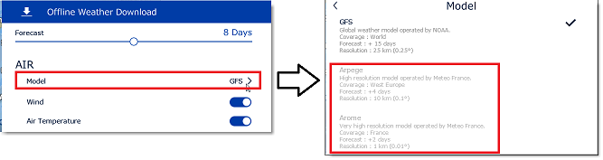
Higher Resolution and Local Models for Weather Forecast
The premium weather subscription provides access to a higher resolution global model (ICON Global) and four higher resolution local models. The Arpege model offers European coverage at a resolution of 10 kilometers and up to 4 days of forecast. The Arome model offers coverage of French coasts and bordering countries at a resolution of 1 kilometer and up to 2 days of forecast. The NAM CONUS model offers coverage for North America at a resolution of 3 kilometers up to 2.5 days of forecast. The ICON Global model offers a worldwide resolution at a 6 kilometers resolution (more than twice the GFS model) up to 5 days of forecast. The premium weather service also offers access to 3 additional wave models.
Once subscribed to the premium weather, you can change the model when requesting a weather file from the "Update" WorkSpace:
Rain Radar & Lightning Strike
IMPORTANT: Because this feature operates in near real time, an active internet connection is required for Rain Radar & Lightning Strike. Unlike weather forecasts, the data cannot be cached for offline use.
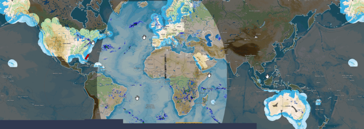
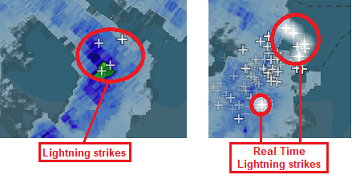
The Rain Radar combines two complementary data sources: ground radar, which provides high-resolution precipitation data in coastal areas, and EUMETSAT satellite precipitation (MSPE H60B), which extends coverage offshore beyond the range of terrestrial radar over the Atlantic ocean. To ensure clear interpretation, the display distinguishes three coverage levels when the Rain Radar & Lightning Strike is displayed: ground radar coverage (no mask), satellite-only coverage (light mask), and areas with no available data (dark mask):
Lightning strikes are displayed across all areas covered by the Rain Radar, allowing precipitation and electrical activity to be interpreted within the same view. Users can clearly observe storm structure, lightning concentration within active cells, and movement over time. This dynamic view enhances understanding of convective development and supports more informed operational decisions.
To display the Rain Radar data, select the "Planning" WorkSpace, click on the "LAYER" button and select "Rain Radar":
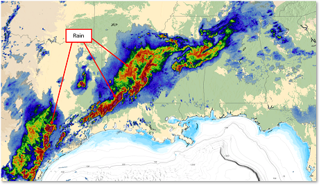
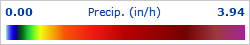
Colors vary according to precipitation intensity, with red and purple indicating heavy precipitation or storms. The color legend is shown in the lower-left corner of the screen and displays values in mm/h or in/h, depending on the unit selected in the Units Options:
New lightning strikes are briefly highlighted, while older ones gradually fade rather than disappearing abruptly. The lightning display time window is user-configurable from 10 to 60 minutes (30 minutes by default) in the Weather Options.
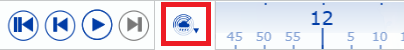
The last three hours of Rain Radar and lightning data can be animated in 10-minute intervals directly on the chart, helping you track storm movement and anticipate where the rain is heading. As precipitation frames update sequentially, lightning strikes appear within developing convective cells and gradually fade as they age, making storm evolution much easier to interpret than with static radar images. To start the rain radar & lightning animation and watch the evolution of precipitation over the last three hours, click on the "play" button located in the timeline at the bottom of the screen. By default, the timeline will automatically adjusts itself in the Rain Radar mode and loop the animation:
Note: You can change the animation speed from the General Options by adjusting the "Animation Replay Speed" setting.
For a more natural animation, you can enable Smooth Weather Animation in the Weather Options. When enabled, temporal interpolation creates smoother visual transitions between frames. When disabled, updates appear more discrete but reflect the raw data more precisely. By default, the setting prioritizes data fidelity over visual smoothing, and Smooth Weather Animation is turned off.
Marine Zone Forecasts (USA only)
IMPORTANT: The Marine Zone Forecast requires an Internet connection. It is not possible to cache the data like it is for weather forecast.
Marine Forecasts are designed to provide you with comprehensive text bulletins, offering a significant advantage over traditional model forecasts. These bulletins are crafted by seasoned meteorologists from NOAA who analyze weather patterns and identify potential hazards, ensuring that you receive information that is both precise and actionable.
Marine Forecast bulletins may also includes specialized sections for alerts and tropical storms, providing timely warnings that are crucial for planning and response strategies.
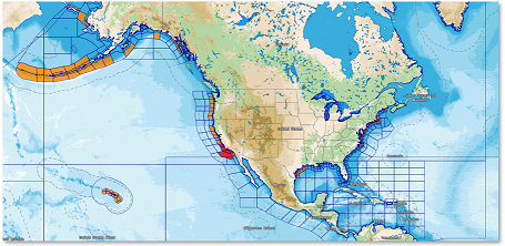
Marine Bulletins are organized into specific zones covering all U.S. territorial waters, each with a unique code name. To display the Marine Forecast Zones layer select the "Planning" WorkSpace, click on the "LAYER" button and select "Marine Forecast Zones":
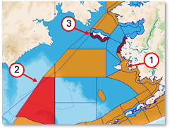
Zones which have an active alert are filled with a specific color depending on the severity:
-
Orange: minor severity
-
Red: moderate severity
-
Dark Red: extreme severity
To display the Marine Bulletin, right click inside the area and select "Show Marine Forecasts". This will open a floating window:
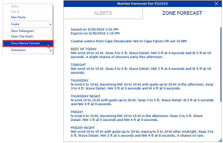
The Marine Forecast window may contain multiple panels:
-
the title, showing the name of the zone.
-
a Zone Forecast Panel, showing the Marine Forecast text.
-
an Alert Panel, that is filled only where an alert is occurring.
-
a Tropical Zone Panel, that is available only in the South part of USA’s East Coast and Gulf of Mexico.
When an alert is active in the zone, the panel title becomes red, and the number of alerts is displayed next to it. An alert starts with a header which will provide the general conditions of the alert:
- Severity of the alert, for example [Minor]
- Type of the alert, for example “Small Craft Advisory”, “Gale Watch”
- Issuance date of the alert
- End date of the alert
- Issuer of the alert, for example “NWS Houston/Galveston TX”
To notify the user of a potential danger (even when the Marine Zones are not displayed on screen), TimeZero will trigger an alarm based on the GPS position when entering a zone with an active alert or when the current zone status changes. The alarm is enabled by default and can be disabled from the Alarms Options under "Marine Forecast Alarm".
Note: When the alarm is enabled (ON by default), TimeZero will check and update the Marine Forecast status in the background, even if they are not displayed on screen. This will use some Internet bandwidth.