Route Wizard & Simulation
Route Wizard
After creating a route, the Route Wizard automatically opens. You can also open it at any time by right‑clicking on an existing route and selecting “Open Route Wizard”:
Note: The automatic display of the Route Wizard can be disabled by turning off “Display Route Wizard after creating a route” in the Routes Options.
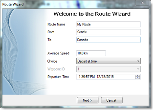
The Route Wizard allows you to define basic route information such as the route name, origin, and destination. More importantly, it helps optimize your trip. Start by entering the average Speed Through Water (STW) that will be applied to all legs of the route for time computation. This speed, combined with currents, is used by TimeZero to compute Speed Over Ground (SOG) and Estimated Times of Arrival (ETA). Next, select one of the following modes:
-
Depart at time: Choose this option when you want to leave at a specific date and time. TimeZero will compute your arrival time using the selected departure time, the average speed on all legs, and the available currents.
-
Best departure time: Use this option when you want TimeZero to determine the most favorable departure time based on currents along the route. TimeZero analyzes current conditions and searches for the optimal departure time within a ±12‑hour window around the selected time, taking your average speed into account.
-
Arrive at time: Select this mode when you want to arrive at your destination at a specific date and time. TimeZero will compute the departure time required to meet that arrival target, based on speed and currents.
-
Arrive at high tide: Use this option when arrival at high tide is required. TimeZero searches within a ±12‑hour window around the selected date and time to find a departure time that allows arrival at high tide at the destination. For this mode to work, a tide station must be available near the final waypoint of the route.
-
Arrive at a waypoint at given time: Choose this mode when you need to pass a specific waypoint at a precise date and time (for example, for a specific tide window or bridges). TimeZero computes the departure time required to meet that constraint, taking currents and average speed into account.
The Best Departure Time mode is often the most powerful option, especially in areas with strong or variable currents. By selecting a more favorable departure window, this mode can significantly reduce transit time and fuel consumption. In the example below, the initial planned departure was set to 5:00 PM on December 19, with an average speed of 7 knots. After analysis, TimeZero determined that departing at noon instead would allow a time savings of more than two hours (over 10% of the total trip duration) thanks to more favorable currents.:
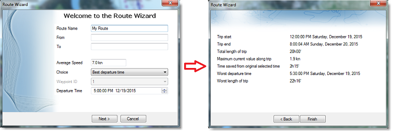
The Route Wizard results page also provides additional useful information, such as the worst departure time within the evaluated window and the maximum current strength encountered along the route. This allows you to compare the worst‑case scenario with the best‑case scenario. If the difference between the two is small, it may indicate that the exact departure time is not critical, and you can choose a more convenient departure time even if it does not correspond to the optimal recommendation.
The Route Wizard should be regarded as a helpful tool to get started with route optimization. When you close the Route Wizard, the computed speed and departure date are automatically applied to the route in the Route Detail table. You can then continue refining and simulating different scenarios directly from the Route Detail table, which is fully dynamic and recalculates results in real time as you adjust parameters (see the next section for details).
Route Simulation
IMPORTANT: The Route Simulation features are only available in the Planning WorkSpace.
When a row of the Route Detail list is selected, or when you click directly on a waypoint, the Timeline at the bottom of the screen automatically switches to Route mode and sets the Chart Time to the ETA of the selected waypoint. A “virtual boat,” shown as a blue ship icon, is also displayed at the corresponding position. This feature is especially useful when weather data or tidal information is visible, as both are automatically adjusted to reflect the predicted conditions at that specific time.
To select a specific row in the Route Detail list, click inside the first grey column located just in front of the corresponding line:
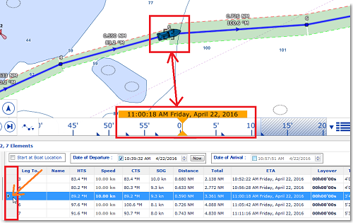
When a row is selected in the Route Detail table, the chart automatically centers on the corresponding waypoint and the Timeline adjusts the Chart Time to match its ETA. Tide gauges, current arrows, and weather data, when displayed on the chart, are refreshed automatically to show the predicted conditions at that waypoint.
Any change to the departure or arrival date, or to the vessel speed (whether applied to the entire route or to individual legs) immediately triggers a new route simulation. TimeZero recalculates the route using the updated parameters and incorporates current data whenever it is available.
Understanding Tidal Currents in TimeZero
TimeZero supports two types of tidal currents: High‑Resolution (gridded) tidal currents and discrete (station‑based) tidal currents.
High‑Resolution tidal currents are only available in North‑West Europe and are purchased separately. These currents are provided as continuous grids, which allows TimeZero to interpolate current speed and direction at any exact position along a route.
Discrete tidal currents are freely available and include NOAA USA Currents and Worldwide Discrete Currents. These currents are derived from individual stations and provide current values at fixed locations. By default, TimeZero automatically selects the station closest to the midpoint of the route leg, provided it falls within a maximum search distance of 5 NM. Users can manually assign a different discrete tidal current station to a specific leg when needed by right‑clicking on the leg, selecting “Assign Tidal Current”, and then choosing the desired current station:
Manual assignment can be useful when the automatically selected station is not representative of local conditions.
Note: This option to manually assign a current station is hidden when the cursor is positioned over a High‑Resolution current area, since gridded currents cannot be manually assigned.
When creating or simulating a route, TimeZero uses tidal currents to compute SOG from the entered STW. These calculations are used in the Route Detail list, the Route Wizard, and optional active route navigation (when the Routes Options “Use Current in Active Route” is enabled). When both High‑Resolution and discrete currents exist in an area, High‑Resolution currents are used automatically whenever they are available. Discrete currents are used only when no High‑Resolution current data is present.
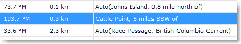
To determine which type of tidal current is used for a given leg, refer to the Tidal Current Name column in the Route Detail list. If High‑Resolution current data is available at the destination waypoint (Leg To), the field displays “Auto.” For discrete currents, the field displays “Auto (name of the tidal current station)” when a station is automatically selected, or simply the station name when a current has been manually assigned. If no tidal current data is available in the area, the field remains blank:
Rather than relying on a single current value for an entire leg, TimeZero performs a detailed integration along the route by internally dividing each leg into multiple sub‑segments. For each sub‑segment, TimeZero evaluates the tidal current at that exact position. When the sub‑segment falls within a High‑Resolution current grid (identified by the tidal current name set to “Auto” in the list), the current value is interpolated at that location. If no High‑Resolution current is available at that position, a discrete current is used instead, either automatically selected or manually assigned by the user.
It is normal for the difference between SOG and STW shown in the Route Detail list to not directly match the displayed tidal current speed. This is because the displayed current speed represents a snapshot evaluated at the waypoint ETA, whereas the actual SOG is computed by integrating current speed and direction along the full length of the leg. In addition, the impact of a current depends on its angle relative to the leg direction, not merely on its raw speed. As the vessel progresses along the leg, both current speed and direction may change, and TimeZero continuously projects the current vector onto the leg direction in order to compute the resulting average SOG.
In some rare situations, TimeZero may display a row in the Route Detail list in red, with missing SOG, ETA and Time to Go values. This indicates that the currents on that leg are too strong for the vessel to maintain effective progress along the planned course. In such cases, the vessel’s speed is insufficient to counteract the current, resulting in an excessive difference between Heading to Steer (HTS) and Course to Steer (CTS), or an inability to make meaningful progress over ground. In most situations, increasing the vessel’s Speed (STW) will resolve the issue. Alternatively, selecting a different departure time or modifying the route to avoid areas of very strong currents may also correct the problem.
Advanced Route Optimization
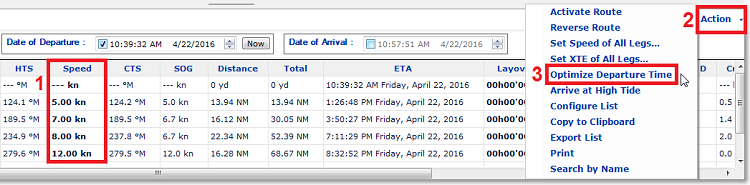
The Route Wizard provides a quick way to compute an optimized route by applying the same default average speed to all legs. However, you can further refine the calculation by assigning individual speeds to specific legs directly from the Route Detail list. To do this, simply enter a custom speed for the desired leg in the STW column. After editing a speed value, the default speed that was previously shown in parentheses (with a faded appearance) changes to a bold font, indicating that a speed constraint has been applied to that leg.
You can repeat this process to fix the speed on additional legs as needed. The Route Detail table automatically recomputes all ETAs as soon as speed values are modified. If you want TimeZero to recompute the best departure time using the newly defined speed constraints, you can run the optimization again directly from the Action menu by selecting “Optimize Departure Time.” Any custom speeds you have set are preserved when running the optimization or reopening the Route Wizard:
When the route is activated, all manually defined speeds are used instead of the speed provided by the GPS, with the exception of the active leg, which always uses the real‑time GPS speed. If you prefer to use the real‑time GPS speed for all legs, you can select “Set Speed of All Legs…” from the Action menu, followed by “Reset Speed to Default.” This removes all manual speed constraints and allows dynamic GPS speed to be used again when activating the route.