Dynamic Lights
This function of the TZ Maps charts intuitively represents lighted aids to navigation (navaid) according to your boat’s position and your field of view. TimeZero takes into account the land topology, the light sector (if present), and the light range to automatically highlight on the chart the relevant navaid. It is also possible to display a NavData that will display in a list the lights ahead of you. All these features will be very useful for any night navigation.
Dynamic Lights Display
Light Range on the chart
TimeZero allows you to quickly visualize on the chart the range of a single lighted navaid.
Just right-click on it and select "Show Light Range":
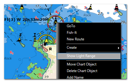
This will display the various light sector(s) (when applicable) with the corresponding color(s) according to the terrain topology.
To hide the light range, simply click anywhere. Repeat this process if you would like to display the range of another light.
Light Display modes
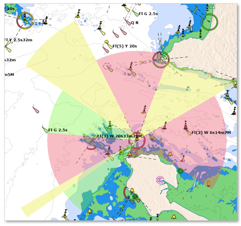
TZ Maps introduces two innovative modes to display the lighted navaids on the charts: "Dynamic" and "Dynamic & Flashing". This option can be adjusted from the Vector Chart settings under "Lights".
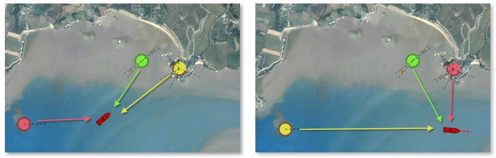
Dynamic:
When "Dynamic" is selected, TimeZero will use your GPS position to determine the lights that are within your field of view and will surround their icon with the corresponding color. This feature is especially useful with light sectors allowing you to confirm at a glance in which sector you are currently located in:
Dynamic and Flashing:
When "Dynamic & Flashing" is selected, TimeZero will in addition make the lights flash on the chart according to the pattern encoded in the vector chart data.
TIP: If you would like the "Dynamic" or "Dynamic & Flashing" modes to only operate when TimeZero is in Dusk or Night mode, just enable the "Restrict to Dusk and Night Modes" option available in the Vector Chart settings under "Lights". This will make the lighted navaids appear normally during the day but use the dynamic presentation at Dusk or at Night.
"Flashing Lights" NavData
A "Flashing Lights" NavData can be configured to the NavData panel. The "Flashing Lights" NavData will display a list of the lighted navaids that are ahead within your field of view sorted by distance. Each item of the list will display the light name, distance and bearing. The leading side of the list will also display the color and flash according to the parameters encoded in the vector chart:
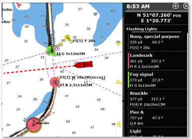
Note: you can Click on any item of the list to find the corresponding light on the chart (TimeZero will automatically center on the light).