Import & Export Data
Backing-up and Restoring Data:
When you want to backup your data or when you want to "clone" your data on another computer, it is recommended to use the "Collection". A collection conveniently groups all objects (routes, marks, objects, tracks, ...), 3D data and layers configuration in one file.
To backup all your data, select "Backup Collection" from the menu.
To restore all your data, select "Open Collection" from the menu.
Note that the charts or settings are not backed up inside a collection. You will have to re-install the charts. The settings are not saved into the collection, however, it is possible to save the user settings by using Save the User Interface from the menu.
IMPORTANT - MERGING DATA: When importing a collection, your current data will be overwritten with the data contained in the Collection. If you want to exchange data with another user (and merge the data) you have to use the TZX format from the "Import/Export" Wizard (see below).
IMPORTANT - SYNCHRONIZATION: Note that if you are using the local synchronization or the TZ Cloud synchronization (to backup data), you should not use collections. Importing an old collection (an old "state" of the user object database) will be overwritten as soon as you connect to the TZ Cloud or to another TimeZero device that may have a newer "state" of the same user objects database. In other words, after importing an old collection, you may see your user objects revert to the previous state automatically when connected to the Internet.
Importing Data
Select "Import/Export" from the menu to import data from the following format:
Note: Imported data is merged with your existing data
Data:
-
TimeZero Exchange (TZX files): this format is used to exchange all type of user objects (including tracks) in between TimeZero users. This format guaranties the full integrity of the data (it supports Routes, Marks, layers, Tracks & Objects).
-
Legacy TimeZero User Data (TZD files): this format is used to exchange data with older version of TimeZero software.
-
GPS Exchange (GPX files): this "open source" format is often used by third party software or converter. It is primary used to exchange Routes and Marks, but you can also import tracks. Note that when importing GPX file from third party application, custom icon and color will be lost.
-
Google Map (KML & KMZ files): this format is primary used to exchange data with Google Earth. Marks, Boundaries (lines / areas), and Tracks are supported.
-
Furuno NavNet 3D (CSV files): this format is used to import Routes and Waypoints from Furuno NavNet3D Multi Function Display. Only Marks and Routes are supported.
-
Nobeltec ONF (TXT files): this format is used to import marks, lines, boundaries, routes and tracks from the legacy software Nobeltec VNS & Nobeltec Admiral.
-
Rosepoint Navigation Object (NOB files): this format is used to import all navigation objects from RosePoint Coastal Explorer.
-
ECDIS Route Format (RTZ files): this format is used to import a single route (one route per RTZ file) from ECDIS systems.
-
MaxSea Layers (PTF files): this format is used to import the marks and tracks from MaxSea "Classic" (v12 and below) that are stored in PTF file(s). Usually PTF files are stored in "My Documents->My MaxSea". Look for any files whose extensions are "*. ptf". Note that the customer might have saved his PTF files to another location. In that case, search for any files having the PTF extension.
-
Olex Plot (GZ files): this format is used to import marks, layers, lines, boundaries and tracks from Olex.
-
P-Sea WindPlot: this format is used to import Marks and Tracks from WinPlot. TimeZero is able to import Marks and Tracks saved in Text format; Marks, Tracks, Routes and Boundaries saved in native Windplot format or backup file.
-
SeaPlot PRO (SPP & ECR files): this format is used to import Marks and Tracks from SeaPlot PRO.
-
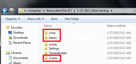
ECC Globe: this format is used to import Marks, Lines and Tracks database files (MDB) from ECC Globe. Usually, the databases file can be found under C:\GLOBE\:
Note that TimeZero 64bits can only import ECC Globe MDB files that were generated with "newer" version of ECC Globe (using Access database 2000 or newer). If you have very old ECC Globe files (that are using Access database 97 or earlier), they will not import in TimeZero 64bits (they might in TimeZero V4 which is 32bits). -
Sodena Turbowin (MDG files): this format is used to import data file from TurboWin 8. TimeZero will import Navigational object data from Turbowin on a folder by folder basis. Simply specify the folder(s) that contain the TurboWin data, and the type of data that you are interested in and the program will locate the correct data files and import it
-
TMQ C-Plot (USR, MRK and TRK files): this format is used to import marks, events boundaries and tracks from C-Plot.
3D Data
This feature is only available with the PBG module
-
TimeZero PBG Data (TZPBG files): this format is used to import 3D depth data, BackScatter and Hardness from another TimeZero user. Note that when importing the data, you will be able to choose which type of data you want to import.
-
Depth Data (XYZ files): this format is used to import generic XYZ depth data or XYZ file(s) generated from MaxSea v12 and below. The generic XYZ format consists of Longitude, Latitude, Altitude. The altitude is in Meters with negative values representing depth:
Ex: -136.0004000 56.9942500 -107.9
Value can be separated by spaces, tabs or commas.
TimeZero also supports the XYZ file from NOAA that have the following header: "survey_id,lat,long,depth,quality_code,active"
Ex: H11371,48.3276139,-122.8239623,42.06,1,1 -
MaxSea Classic PBG (PTZ files): this format is used to import MaxSea 3D user data (.ptz files). Usually the PTZ file is located in "My Documents->My MaxSea". Look for a file named "3DDB.PTZ".
Note: The 3DDB.GRZ file only contains basic 3D data and cannot be imported in TimeZero. All the PBG user data is stored in a single file (the "3DDB.PTZ" file).
-
Olex Depth Data (GZ & OL3 files): this format is used to import Olex 3D user data
-
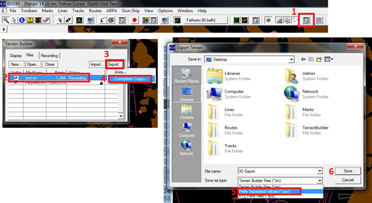
ECC Globe: this format is used to import ECC Globe Terrain Builder 3D user data. Please note that TimeZero can only import 3D data from ECC Globe that has been exported as ".PSV" files. Refer to the screenshot below to export the 3D data from Globe in the correct format:
-
Nobeltec Bathy Recorder (BTH files): this format is used to import "Bathy Recorder" user files recorded with Nobeltec VNS or Admiral.
-
Sodena Turbowin Depth Data: this format is used to import 3D user file from TurboWin 8. By default, TurboWin places its user generated bathy files in a sub folder named UDB_UserBathy in the Database folder located under the program's main installation folder.TimeZero will import the bathy data from Turbowin on a folder by folder basis. Simply specify the folder(s) that contain the turboWin bathy data and the program will locate the correct data files and import them.
-
Legacy TimeZero v2.0 (PTZ2 files): This format is used to import 3D data that has been previously imported in MaxSea or Nobeltec TimeZero v1 (with v2 and above, TZPBG files are used instead).
When importing 3D data, you can restrict the points that get imported by entering a depth range (minimum and maximum). Entering a tight range corresponding to your fishing area is the best way to filter out bad points that may be inside the 3D file you are importing. You can also select "Remove points using statistical analysis", but this is only efficient in areas with moderate slope. Do not use this options in area that have lots of changes in the terrain as this might filter out good depth points.
Images
-
JPEG: this format is used to import and geo-referenced photos (pictures are automatically placed on the charts). In order to be imported, the photo must either embed the lat/lon or a time/date that can be correlated by TimeZero with a GPS position.
Exporting Data:
Select "Import/Export" from the menu to export data in the following format:
Data
-
TimeZero Exchange (TZX files): this format is used to exchange all type of user objects (including tracks) in between TimeZero users. This format guaranties the full integrity of the data (it supports Route, Marks, layers, Tracks & Objects).
-
Legacy TimeZero User Data (TZD files): this format is used to exchange data with older version of TimeZero software.
-
GPS Exchange (GPX files): this "open source" format is often used by third party software or converter. It is primary used to exchange Routes and Marks, but you can also export tracks.
-
Google Map (KML & KMZ files): this format is primary used to exchange data with Google Earth. Marks, Boundaries (lines / areas), and Tracks are supported. Note that routes will be exported as lines.
-
Furuno NavNet 3D (CSV files): this format is used to export Routes and Waypoints to Furuno NavNet3D Multi Function Display. Only Marks and Routes are supported.
If you want to only export a couple of Routes or Marks, use the "Actions" menu of the Route List or Mark List:
-
-
-
Open the "Route List" or "Mark List" from the "Lists" button in the Ribbon
-
Select one line on the list by clicking inside the first grey column in front of the specific line (or select multiple lines using the CTRL or SHIFT key)
-
Click on the "Action" menu and select "Export Selected Route/Marks"
-
Select the export format
-
Select the location, give a name to the file and then validate.
-
-
3D Data
This feature is only available with the PBG module
-
TimeZero PBG Data (TZPBG files): this format is used to export 3D depth data, BackScatter and Hardness to another TimeZero. Note that when exporting the data, you will be able to choose which type of data you want to import.
-
Depth Data (XYZ files): this option allows to export your 3D PBG data (Mono Beam only) in a standard XYZ format. This is useful if you want to export your 3D data to another GIS. Please note that this DOES NOT export the 3D data may have been imported. This only exports the 3D data that has been generated inside TimeZero. The format is lat, lon, elevation with depths represented by negative values in meters:
Ex: -124.272242954799, 46.7432681482846, -8.1
Note: It is NOT possible to export XYZ depth data created from WASSP.