Parallel Line
A route leg parallel line is an advanced plotting tool can be setup on any leg of a route (one parallel line per leg) and used for dead reckoning (in case you lose GPS position). Simply right click on a route leg and select "Parallel Line". A dashed line (parallel to the route leg) will be attached to your cursor with bearing and distance (in between line and route leg) displayed under the cursor:
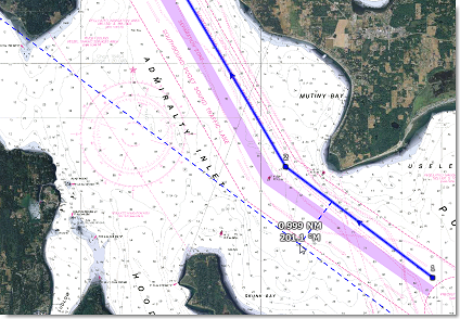
To drop the parallel line, just left click. Once dropped, you can drag the parallel line to make adjustment and the new distance will be updated on the parallel line itself. Note that the parallel line extends beyond the leg boundary so that you can align the line with landmark or NavAid that may be located far away. If you move the leg, the parallel line will also update (to stay parallel to the route leg).
A typical use of the parallel line is to take a fix object that can be seen on your radar and use it as a reference:
-
Create a route in TimeZero
-
Identify a fix object that can be seen on the radar (Coast Line, NavAid, Landmark,...)
-
Locate that object on the chart and create a parallel line that intersects that object. Note the distance.
-
Set a parallel line on the radar at the same distance
-
In case you lose GPS, simply make sure that the parallel line on the radar stays on the object radar return, and you will know that you follow the route segment for which the parallel line was drawn
It is possible to change the color of the parallel line by right clicking on it.
To delete the parallel line, simply right click and select "Delete Parallel Line".
Note: The Parallel Line(s) will only show on routes which are selected (planning) or Active.