Route Detail
The Route Detail provides a tabular view of the selected route and displays detailed information for each leg, including distances, speeds, estimated times, and current information. It is primarily used during route planning to simulate navigation conditions and calculate Estimated Times of Arrival (ETA). TimeZero automatically computes Speed Over Ground (SOG) for each leg based on the user‑entered Speed Through Water (STW) and the tidal and oceanic currents available along the route.
Opening and Closing the Route Detail
Note: Although you can display the Route Detail in the Navigation WorkSpace, it is highly recommended to work with the Route Detail in the Planning WorkSpace (that provides simulation functions with the Timeline located at the bottom of the screen).
In the Planning WorkSpace, right‑click on a leg of the route you want to review and select Route Detail. Alternatively, you can double‑click on any leg of the route to open the route details directly:
To close the Route Detail, click the "X" button at the top right of the route detail list.
Note: Some legs may appear in red. This indicates either that currents are unusually strong on that leg or that Route Safety has detected a potentially unsafe area or depth.
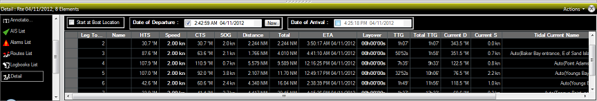
Using the Route Detail
The top portion of the Route Detail allows you to set either a departure time or an arrival time. When a departure time is selected, TimeZero calculates ETA based on vessel speed (STW) and environmental conditions (Tidal Currents and/or Oceanic Currents). When an arrival time is selected, TimeZero works backward to determine the appropriate departure time. This is particularly useful when planning routes influenced by tidal windows or strong currents.
Values shown in bold within the table can be edited by double-clicking the corresponding cell. After making a change, press Enter or click outside the field to confirm it, or press Esc to cancel. Editable fields include the waypoint name, waypoint position, speed (STW), cross-track error (XTE), radius, comment, and layover time. All other values are calculated automatically by TimeZero and cannot be modified directly.
Some editable fields (such as STW, Radius, or XTE) may display a value in parentheses with a faded appearance. This indicates that the value is using the default settings (typically configured in the Routes Options). If these values are not manually changed, they will automatically update when the default settings are modified. However, once you edit a value, it appears in bold (without parentheses), indicating that a custom constraint has been applied.
Below is an overview of the columns available in the Route Detail table:
-
Leg To: Each row provides information about the leg leading to a specific waypoint. The “Leg To” value corresponds to that waypoint number.
-
Name: The name of the waypoint.
-
HTS (Heading to Steer): The heading to follow to reach the next waypoint, adjusted for currents. This may differ from CTS when currents are significant.
-
STW (Speed Through Water): The vessel’s speed through the water. This can be set individually per leg or globally via the Action menu. To revert to the default value, simply clear the cell.
-
CTS (Course to Steer): The bearing of the route leg as it would appear on a paper chart.
-
SOG (Speed Over Ground): The vessel’s actual speed over the ground, calculated using STW and current effects. This may differ from STW due to currents speeding up or slowing down the vessel.
-
Leg Length: The distance of the leg.
-
Total: The cumulative distance from the start of the route to that leg.
-
ETA (Estimated Time of Arrival): The expected arrival time at the waypoint, taking currents into account (based on SOG).
-
XTE (Cross Track Error): The allowable deviation from the route. This can be set per leg or globally via the Action menu. To reset to the default value, clear the cell.
-
Radius: The waypoint automatic switching circle radius. Please refer to Waypoint Switching Mode for more information.
-
Layover: Allows you to insert a stop or pause at a specific waypoint.
-
TTG (Time to Go): The time required to complete the leg, calculated using SOG and distance.
-
Total TTG: The cumulative time from the start of the route to that leg.
-
Current D: With Discrete Currents, this value corresponds to the current direction from the nearest station to the midpoint of the leg (or from a manually assigned station). With High-Resolution Currents, this value is extrapolated at the waypoint position (Leg To).
-
Current S: With Discrete Currents, this value corresponds to the current speed from the nearest station to the midpoint of the leg (or from a manually assigned station). With High-Resolution Currents, this value is extrapolated at the waypoint position (Leg To).
-
Tidal Current Name: If High Resolution current data is available at the waypoint position (Leg To), the field displays “Auto”. For Discrete Currents, it displays “Auto (name of the tidal current station)” when automatically selected, or simply the station name when manually selected. If no tidal current data is available in the area, the field remains empty.
-
Tide Level: The tide height at the station closest to the waypoint.
-
Comment (hidden by default): Comment associated with the waypoint.
-
Current Angle (hidden by default): The angle of the current relative to the vessel’s bow.
-
Position (hidden by default): The geographic position of the waypoint.
-
Tide Name (hidden by default): The name of the tide station closest to the waypoint.
-
Wheel Over Distance (hidden by default): Distance remaining before the vessel should begin the turn toward the next leg when the wheel over mode is enabled. For more information, please refer to the Waypoint Switching Mode chapter.
-
Wheel Over Time (hidden by default): Time remaining before the vessel should begin the turn toward the next leg when the wheel over mode is enabled. For more information, please refer to the Waypoint Switching Mode chapter.
The Route Detail “Action” menu, located in the title bar on the right side of the list, provides quick access to key functions and settings:
-
Activate Route: Starts navigation on the planned route. This option is unavailable in Home Planning mode or when no GPS position is available.
-
Reverse Route: Reverses the direction of the route.
-
Set Speed of all legs: Set a speed or resets the speed for all legs.
-
Set XTE of all legs: To adjust or reset the Cross Track Error of all the legs
-
Optimize Departure Time: Calculates the best departure time based on currents (see next chapter for details)
-
Arrive at High Tide: Calculates the departure time needed to reach the destination at high tide (see next chapter for details)
-
Configure List: Adds or removes columns in the Route Detail table.
-
Copy to clipboard: Copies the displayed table data for use in another application (e.g., text editor or Excel).
-
Export list: Exports the table data as a text file, with fields separated by tabs.
-
Print: Prints the route detail voyage plan.
-
Search by Name: Allow to search and center on a specific waypoint by name.