Routing Detail
The "Routing Module" needs to be unlocked to access this feature
The Routing Detail is very similar to the Route Detail. It displays information about the selected routing in a tabular format together with information about the routing as a whole (date of departure, weather file used for computation, etc...). Unlike the Route Detail, the Routing Detail cannot be modified. If you want to modify a parameter (date of departure for example), a new routing must be launched.
Opening and Closing the Routing Detail
Note: Although you can display the Routing Detail in the Navigation WorkSpace, it is highly recommended to work in the Planning WorkSpace (that provides the Time Bar).
Select the Planning WorkSpace, zoom in on the optimized route and double click on it (double click on one of the green leg).
To close the Route Detail, Click the "X" button at the top right of the route detail list.
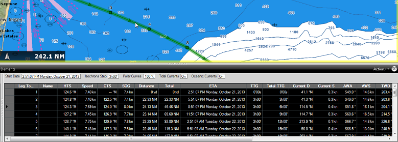
Using the Route Detail
The top part of the Routing Detail displays information about the routing itself:
-
Start Date: The Routing date of departure
-
Isochrons Steps: The step in between two isochrons displayed on the chart. In most cases (if there is no tack in between two isochrons), this will also be the step in between two legs.
-
Polar Curves %: Indicates the polar percentage factor that was used for the computation of this routing.
-
Tide Current, Oceanic Current, and Waves: Indicates if these parameters are taking into account for this routing (can be adjusted from the Routing Options).
The table display for each leg various useful information that can be displayed, hide or reorder from the "Action" menu:
-
Leg To: Each line of the list gives you information about the leg that allows to reach a specific Waypoint. The "Leg To" value is the number of that Waypoint.
-
ETA: The Estimated Date of Arrival to that Waypoint taking account the currents (based on SOG).
-
Speed: speed through water of the boat (or surface speed). This value can be edited individually for each leg or can be set globally (for all legs) using the Action menu.
-
HTS: Heading to Steer. This is the heading that you should follow to reach the next waypoint. This value is adjusted to take the currents into account. This value can be different from the CTS if currents are strong in the area.
-
SailSet: is the SailSet used for this leg according to Wind Angle, Speed and the SailSet table defined in the Polar WorkSpace.
-
SOG: Speed over Ground being calculated based upon the surface speed and currents. The SOG will be different that the speed, because your boat can be "pushed" or "slow down" by the currents.
-
CTS: The "Course to Steer" is the direction (bearing) of the route leg as it would be on a paper chart.
-
TWS: is the True wind Speed
-
TWA: is the True Wind Angle
-
TWD: is the True Wind Direction
-
Waves H: is the Wave Height
-
Distance: is the distance of that leg
-
Total TTG: is the cumulative time to go from the start of the route to that leg
-
AWA: is the Apparent Wind Angle
-
AWS: is the Apparent Wind Speed
-
Current D: is the current direction
-
Current S: is the current speed
-
Name: an optional name you can set on a specific waypoint
-
Position: is the position of the waypoint
-
Total: is the cumulative distance from the start of the route to that leg
-
TTG: "Time to Go" is the time to navigate on that leg. The SOG and Distance are used to compute that value.
-
Variability: is the variability on that leg
-
Waves D: is the Wave Direction
-
Waves P: is the Wave Period
Note: Current, AWA, AWS, TWD, TWS, Waves are values coming from the Weather File.
The Route Detail "Action" menu provides quick access to main functions and parameters. It can be found on the right side title bar of the list. It includes the following options:
-
Convert to Route: To convert a routing (which has fixed constraint and cannot be edited) to a route that can be freely edited.
-
Activate Route: To activate the planned route and start navigating. Note that this option is not available when TimeZero is started in Home Planning mode or when no position (GPS) is available.
-
Configure List: To add or remove columns of the Route Detail table
-
Copy to clipboard: To copy the list information as displayed on your screen. You can paste this information in a text editor or Excel for further editing
-
Export list: To export the list information as displayed on your screen in a text file. Each field is separated by a Tab
-
Print: To print the list as displayed on your screen.
-
Search by name: To locate in the list a waypoint with a specific name.