Displaying and Configuring NavData
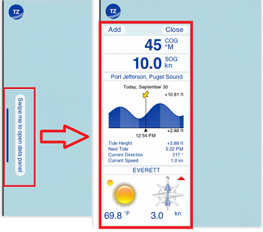
Various types of data can be displayed from a new NavData screen. This screen can be configured with multiple “NavData”. To open the NavData screen, simply tap your finger on the NavData button at the bottom of your screen:at the bottom of your screen:
To add a new NavData, click on the “Add” button located on the top right of the panel. If you want to modify an existing NavData (for example, change the data it displays), simply tap on it and select the new data type. To remove a NavData from the panel, tap on it and select Remove NavData.
There are multiple types of NavData:
-
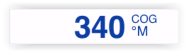
Numerical NavData: used to display a sensor value (Speed, Depth, Wind…) or the Active Route data (Time to Go, Cross Track Error…) using text:
TIP: When you activate a route, steering and route data will automatically appear at the top of your screen in the Active Route header (you do not necessarily need to create a NavData). You can cycle in between multiple values by tapping on the header.
-
Graphic NavData: to display a sensor value using a graphic gauge:
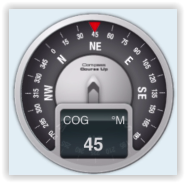
To configure a gauge NavData, first add a numerical NavData with the data you want to display, then tap on it and enable “Graphic” from the Pop-Up menu. -
Tide NavData: to display the closest tide station information as a small graph, and when applicable, the closest tidal current direction and speed.
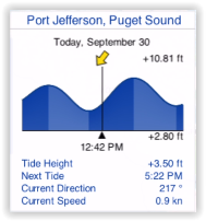
Note: the maximum search distance for tide is 50NM. If there is no tide station located within that radius, the Tide NavData will not display any information.
-
Current NavData: to display the closest tide station information as a small graph, and when applicable, the closest tidal current direction and speed.
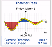
Note: the maximum search distance for current is 5NM. If there is no current station located within that radius, the Current NavData will not display any information.
-
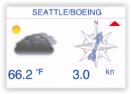
Real Time Weather NavData: to display real time weather from the closest METAR station (requires Internet connection)
-
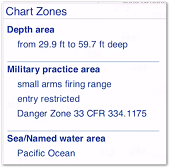
Chart Zones NavData: to display a list of all the chart areas your vessel is currently in. For more information, please refer to the Smart Zone chapter.
-
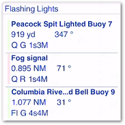
Flashing Lights NavData: to display a list of the lighted navaids that are ahead within your field of view sorted by distance. For more information, please refer to the Dynamic Lights chapter.