Introduction
The “SportFishing Ocean-O” service enables sport fishing enthusiasts to find the best fishing spots based on oceanographic conditions!
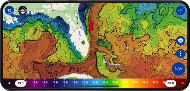
In addition to the meteorological data available in the “Weather Premium” service, you'll have access to new information: water surface temperature (SST), altimetry (SSH), chlorophyll concentration and currents.
The SportFishing Ocean-O service provides access to the following datas:
- The SST (Sea Surface Temperature) is of prime importance. Identify the zones where fish concentrate according to their thermal comfort. Locate thermal fronts, natural frontiers rich in marine life.
- Chlorophyll concentration is essential, as there's a well-known correlation between it and the location of phytoplankton, which forms the basis of the food chain for the fish you're looking for. Larger fish such as tuna are more likely to be found at the edge of areas with high chlorophyll concentrations.
- Altimetry (SSH: Sea Surface Height) is invaluable. Find upwelling zones, where nutrients rise from the depths to attract fish and prey.
- Currents, you'll be able to identify areas of strong currents, clearly visible thanks to the large arrows drawing river-like patterns in the open sea. This will enable you to identify areas called Eddies, which trap nutrients and thus favor the presence of the species you're looking for.
This data can be represented by color gradients or contour lines.
Six predefined layers are available to display your data on the map, both in surface mode and in contour line mode, which can be superimposed on each other (for more information, see “How to choose layers”).
By analyzing the various data layers, superimposing them and cross-referencing information on temperature, chlorophyll and currents, you'll be able to pinpoint those strategic areas where fish congregate. It's an innovative and crucial approach to maximizing your chances of fishing success!
This data is automatically retrieved in real time if you have an Internet connection, with the “Online” mode activated by default. If you don't have an Internet connection during your navigation, you'll need to download the ocean forecasts before setting out to sea - this is the “Offline” mode (for more information, see the “Online or Offline mode" chapter).