Proprietary Sentence & File Format
Proprietary sentences provide a means for manufacturers to use the sentence structure definitions of NMEA 0183 standard to transfer data which does not fall within the scope of approved sentences. Below are the proprietary sentences recognized and used by TimeZero.
"$PMXS, CURSOR" NMEA Sentence
This sentence can be used to display in TimeZero the location of an external cursor (or generic external position such as second GPS or ROV). The position will be displayed with a green square and can be show/hidden from the "Own Ship" button located in the ribons.
$PMXS,CURSOR,llll.ll,a,yyyyy.yy,a*hh
Note: An external tool converting a regular GPS sentence into $PMXS, CURSOR is available. This can be useful to position a second GPS or ROV (sending regular position sentence) into TimeZero.
POSREPORT file format
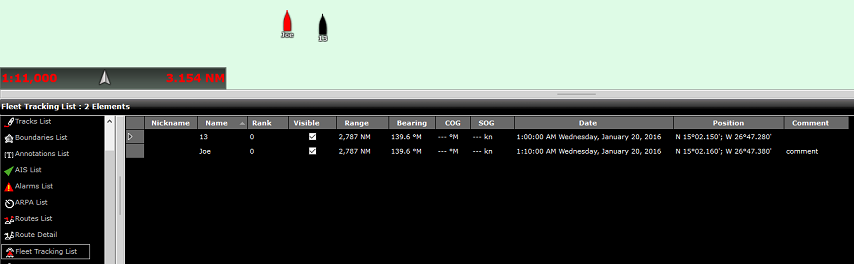
TimeZero can scan a folder (defined in the Targets Options under "Vessel Tracking Data Location") for new or updated text file(s) containing position report information. Once TimeZero detects a new file in that folder, it analyzes it and displays the location of the target(s) on screen.
TimeZero supports two formats: the traditional "POSREPORT" format and the "simplified" format.
POSREPORT Format
The POSREPORT text file always start with “POSREPORT”, then one line per target with the fields separated by “;”.
Fields Definition:
-
Rank (int)
-
Name or ID (string)
-
Latitude (string, degrees.minutes(2 fixed digits)decimal)
ex: N 44°54.074' = 44.54074N -
Longitude (string, degrees.minutes(2 fixed digits)decimal)
ex: W 034°42.018' = 34.42018W -
Date (UTC, format MM/DD/YY hh:mm(:ss optional) )
-
Comment (string)
Example:
POSREPORT
0;13;15.0215N;26.4728W;01/20/16 09:00:00;
0;Joe;15.0216N;26.4738W;01/20/16 09:10;comment
Simplified POSREPORT Format
The text file contains one line per target with each line starting with "//TM/POS". Then, the following parameters (key value/pair) are used (the order is not important).
-
//OP/xxxxxx is used for the target name or ID (string)
-
//LT/xx.xxxx is used for the latitude of the target (string: degree.decimal N = + / S = -)
-
//LG/xx.xxxx is used for the longitude of the target (string: degree.decimal E = + / W = -)
-
//DA/xxxxxx is used for the date of the position (string: YYYYMMDD)
-
//TI/xxxxxx is used for the time of the position (string: HHMMSS)
Example:
//TM/POS//OP/My Name//LT/-16.4056//LG/-73.2195//DA/20120526//TI/141530
Note: TimeZero deletes the file after reading it.
Fishing Buoys file format
TimeZero will check periodically the content of a directory, specified in the Targets Options under "Fish Buoys Data Location". If a file with a name following the pattern *_PosReport*.* is present, TimeZero analyzes it and display the Buoys on screen.
The text file contains data that looks similar to NMEA sentences. Each line starts with $MXMIT with all the fields separated by comas.
Fields Definition:
ID- string(8) - Identifier
ALIAS - string(20) - Name
Date Utc – 220709 - DDMMYY
Time Utc – 125632 - HHMMSS
Latitude - 003.8955 (like NMEA sentence)
Hemisphere - [N,S]
Longitude - 122.9486 (like NMEA sentence)
Meridian - [E,W]
Vcc - 00.0 – Battery voltage
Temp - [00.0] - Temperature
Flash - [0,1] - not used
Battery alarm - [0,1] - not used
Speed alarm - [0,1] - not used
Remote command active - [0,1] - not used
Example:
$MXMIT,M2I51041,Buoy,060710,125851,042.1363,N,008.8022,W,11.7,37.7,0,0,0,0
Note: For each buoy, TimeZero accepts only new positions dated after last position. TimeZero deletes the file after reading it. To erase the buoy from TimeZero (reset the buoy deployment date), a sentence with empty date and time can be used.
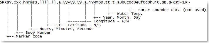
"$PRBY" Fishing Buoy NMEA Sentence
TimeZero is compatible with the propriatary NMEA sentence "$PRBY" that is used to receive Fishing Buoys information. This sentence is used by the Japanese buoys manufacturer "Ryokusei":
"$GBBLV" Fishing Buoy NMEA Sentence
TimeZero is compatible with the propriatary NMEA sentence "$GBBLV" that is used to receive Fishing Buoys information. This sentence is used by the Japanese buoys manufacturer "Ryokusei":
$GBBLV,,3554.330,N,14009.660,E,,,,,,,,,,,232210,,15.0,*5B<cr><lf>
Field1: blank
Field2: Latitude
Field3: N/S
Field4: Longitude
Field5: E/W
Field6-15: blank
Field16: Buoy ID in six order
Field17: blank
Field18: SST
Field19: Checksum