NavData Types
Various types of NavData can be displayed in TimeZero:
Sensors NavData
The Sensor NavData is used to display numerical values received from sensors connected to the computer. The font color is white for data that is received directly from a sensor and yellow when the data is being computed by TimeZero from a sensor:
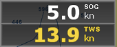
Note: In the example, above, Speed Over Ground (SOG) is displayed in white because it is directly received from the GPS. The True Wind Speed (TWS) is displayed in yellow because it is computed by TimeZero from Apparent Wind (received from the sensor) and Speed.
The following Sensor NavData are available:
-
Date/Time
-
Boat Position
-
COG - Course Over Ground
-
SOG - Speed Over Ground
-
DPT - Depth
Note: The Depth can be configured to display the value below the keel or below sea level using the "Depth Display" from the Initial Setup Options
-
SST - Sea Surface Temperature
-
HDG - Boat Heading (can be computed by TimeZero from SOG when the speed is over 1kn)
-
STW - Speed Through Water (also known as Speed Over Water)
-
STW(tr) - Transverse Water Speed
-
Set - Current Direction (can be computed by TimeZero from COG, STW, Heading and SOG)
-
Drift - Current Speed (can be computed by TimeZero from COG, STW, Heading and SOG)
-
TWD - True Wind Direction. If True Wind Direction is not sent by the wind sensor, it can be computed by TimeZero from Apparent Wind Angle with Heading/Speed through Water ("Surface" reference) or COG/SOG ("Ground" Reference). "Surface" or "Ground" can be selected from the Initial Setup Options ("True Wind and VMG Calculation")
-
TWA - True Wind Angle. If True Wind Angle is not sent by the wind sensor, it can be computed by TimeZero from Apparent Wind Angle with Heading/Speed through Water ("Surface" reference) or COG/SOG ("Ground" Reference). "Surface" or "Ground" can be selected from the Initial Setup Options ("True Wind and VMG Calculation")
-
TWS - True Wind Speed. If True Wind Speed is not sent by the wind sensor, it can be computed by TimeZero from Apparent Wind Speed and Speed through Water ("Surface" reference) or SOG ("Ground" Reference). "Surface" or "Ground" can be selected from the Initial Setup Options ("True Wind and VMG Calculation")
-
AWA - Apparent Wind Angle
-
AWS - Apparent Wind Speed
-
VMG - Velocity Made Good. If VMG is not received, it can be computed by TimeZero from True Wind Direction and Speed through Water ("Surface" reference) or SOG ("Ground" Reference). "Surface" or "Ground" can be selected from the Initial Setup Options ("True Wind and VMG Calculation").
-
Atmospheric Pressure
-
Air Temperature
-
Humidity
-
HDOP
-
Trip Distance
-
Trip Time
-
Rudder
-
Boat Position Lat/Lon: always displays the boat position in Lat/Lon even if another unit has been selected as coordinate system.
-
% Polar: Only available with the Routing module
-
Bottom Hardness %: Only available with the Bottom Hardness module
-
Door Spread: Only available with the Trawl Positioning module
-
Trawl Off-center: Only available with the Trawl Positioning module
-
Pitch
-
Roll
-
Heave
-
Fuel Time to Empty (computed by TimeZero from Fuel Tank Level and Fuel Rate)
-
Fuel Distance to Empty (computed by TimeZero from Fuel Tank Level, Fuel Rate and Speed)
-
Fuel Rate
To change the data displayed in a sensor NavData, just right click and select a new data from the contextual menu. The NavData will be immediately updated and display the selected data.
It is possible to configure one NavData to cycle through multiple data. Just right click on the NavData, select "Add" and choose the data you want to add. The NavData will begin to cycle between the two data. You can repeat this operation and add more data to cycle through. To stop the cycle, uncheck all data from the "add" contextual menu.
Note: The cycle speed can be changed from the General Options by adjusting the "NavData Multi Data Dwell Time" setting.
Route NavData
Route NavData are used to display various numerical values linked to the Active Route computed by TimeZero. Note that by default an "Active Route NavData" giving you basic information about the active route is configured inside the "Navigation" NavData panel. If that does not give you enough information, Route NavData can be configured manually. Note that if a route or Go To is not activated, the Route NavData will display dashes ("--"). The font color of the Route NavData is red:
![]()
The following Route NavData are available:
-
BTW - Bearing to Waypoint: indicates the course to steer from the vessel’s current position to reach the active waypoint. This value does not take currents into account and represents the theoretical course as it would be drawn on a chart. It corresponds to the CTS (Course to Steer) value shown in the Route Detail list.
-
HTS - Heading to Steer (real time): indicates the actual heading required to reach the active waypoint while accounting for real‑time effects such as wind and ocean or tidal currents. This value is continuously computed by TimeZero from the CTS and the vessel’s measured drift vector. For the real‑time HTS to be accurate, reliable drift information is required, which in turn depends on an accurate heading sensor and a precise Speed Through Water (STW) sensor.
-
HTS - Heading to Steer indicates the heading required to reach the active waypoint when applying tidal current data embedded in TimeZero, based on planned or simulated conditions rather than real‑time sensor input.
Note: The HTS will display the same value as CTS if there is no Tidal Currents near the Active Leg.
-
NEXT - Next Course: indicates the CTS to follow after the next Waypoint. This is useful to see if a major course change is needed after passing the Active Waypoint.
-
TTG - Time To Go (using VMC): indicates the estimated time required to reach the active waypoint. This value is computed by TimeZero using the Distance to Waypoint (DTW) and the VMC (Velocity Made on Course), which represents the vessel’s effective speed toward the waypoint..
-
DTW - Distance To Waypoint: indicates the distance remaining to reach the Active Waypoint from own ship position.
-
XTE - Cross Track Error: indicates the lateral distance by which the vessel is offset from the straight line between the previous waypoint and the active waypoint. For the first waypoint of a route, or when navigating to a Go To point, the reference line is drawn from the position where the route was activated.
-
ETA - Estimated Time Arrival: indicates the arrival date and time taking into account the Tidal Currents along the route and the real time speed.
-
TTA - Time To Arrival: indicates the time remaining to reach the end of the route taking into account the Tidal Currents along the route and the real time speed.
-
DTA - Distance to Arrival: indicates the distance remaining to reach the end of the route.
-
VMC - Velocity Made good on Course: indicates the vessel’s effective speed toward the active waypoint. TimeZero computes this value from the component of Speed Over Ground (SOG) that is aligned with the direction to the active waypoint. In other words, it represents how fast the vessel is actually approaching the waypoint.
-
WOT - Wheel Over Time: indicates the estimated time remaining before the vessel reaches the Wheel Over Point, based on the current or planned speed and the vessel’s Rate of Turn.
-
WOD - Wheel Over Distance: indicates the remaining distance from the vessel (or previous waypoint, depending on route state) to the Wheel Over Point where the turn toward the next leg will begin.
To change the data displayed in a Route NavData, just right click and select a new data from the contextual menu. The NavData will be immediately updated and display the selected data.
It is possible to configure one NavData to cycle through multiple data. Just right click on the NavData, select "Add" and choose the data you want to add. The NavData will begin to cycle between the two data. You can repeat this operation and add more data to cycle through. To stop the cycle, uncheck all data from the "add" contextual menu.
Active Route NavData
When a route is activated, the Active Route NavData displays Distance, Time To Go and Estimated Time of Arrival of each waypoint:
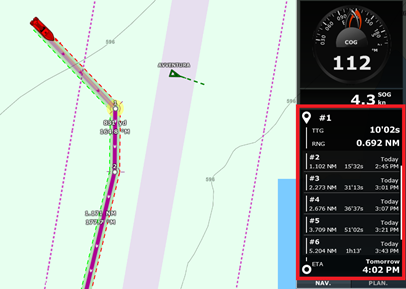
When a route contains many waypoints that cannot all fit within the NavData area, you can scroll the NavData content to view information for upcoming waypoints. The final waypoint (the destination) is always shown at the bottom of the NavData list.
The NavData automatically expands or contracts to fill the available space within its container. If the NavData is undocked, you can right‑click on it to define how much space it occupies, allowing you to display 5, 10, or 15 waypoints.
You can also right‑click on the NavData to configure which information is displayed. In particular, you can choose to show only named and/or flagged waypoints, which is useful when you want to focus on a reduced set of key waypoints.
Note: You can rename or flag a waypoint by right-clicking on it and selecting the appropriate option from the menu.
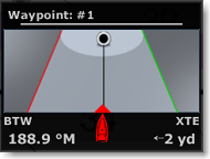
Waypoint NavData
The Waypoint NavData displays information related to the active waypoint. It combines a “highway” display (also known as the Helmsman display) with Cross‑Track Error (XTE) and Bearing to Waypoint (BTW) information on a single screen.
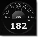
Gauge NavData
Gauge NavData are used to display values received from sensors connected to the computer in a graphic "gauge" type display. The font color is white for data that is received directly from a sensor and yellow when the data is being computed by TimeZero from a sensor:
The following Gauge NavData are available:
-
Date/Time
-
Bearing To Cursor
-
TWD - True Wind Direction. If True Wind Direction is not sent by the wind sensor, it can be computed by TimeZero from Apparent Wind Angle with Heading/Speed through Water ("Surface" reference) or COG/SOG ("Ground" Reference). "Surface" or "Ground" can be selected from the Initial Setup Options ("True Wind and VMG Calculation")
-
TWS - True Wind Speed. If True Wind Speed is not sent by the wind sensor, it can be computed by TimeZero from Apparent Wind Speed and Speed through Water ("Surface" reference) or SOG ("Ground" Reference). "Surface" or "Ground" can be selected from the Initial Setup Options ("True Wind and VMG Calculation")
-
Atmospheric Pressure
-
Air Temperature
-
COG - Course Over Ground
-
SOG - Speed Over Ground
-
DPT - Depth
Note: The Depth can be configured to display a value below the keel or below sea level using the "Depth Display" from the Initial Setup.
-
SST - Sea Surface Temperature
-
HDG - Heading (can be computed by TimeZero from SOG when the speed is over 1kn)
-
STW - Speed Through Water (also known as Speed Over Water)
-
TWA - True Wind Angle (can be computed by TimeZero from Apparent Wind and STW or Apparent Wind and SOG)
-
AWA - Apparent Wind Angle
-
AWS - Apparent Wind Speed
-
VMG - Velocity Made Good
-
Total Fuel Flow
-
Fuel Flow #1
-
Fuel Flow #2
-
Fuel Flow #3
-
Fuel Flow #4
Most of the Graphic NavData scale can be adjusted from the Initial Setup Options under "Graphic Instruments Setup".
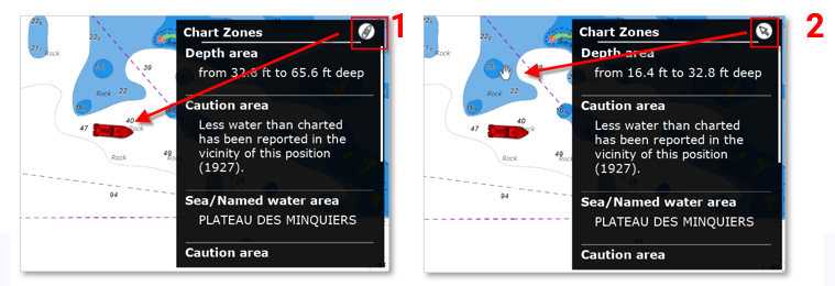
Chart Zone NavData
The Chart Zone NavData displays various information related to the vector chart of all areas you are in. By default this information corresponds to the zones located under the boat. By clicking on the boat symbol (1) at the top right of the NavData "Chart Zone" you can switch to Cursor mode (2).
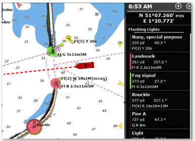
Flashing Lights NavData
The "Flashing Lights" NavData will display a list of the lighted navaids that are ahead within your field of view sorted by distance. Each item of the list will display the light name, distance and bearing. The leading side of the list will also display the color and flash according to the parameters encoded in the vector chart:
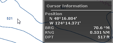
Cursor NavData
The Cursor NavData displays various information related to the cursor position on the screen:
If you right click on the Cursor NavData you can configure what information you want to display.
The following data can be displayed inside the Cursor NavData:
-
Position: indicates the position of the cursor on the screen using the position unit selected from the Units Options.
-
Position Lat/Lon (hidden by default): indicates the position of the cursor on the screen using the Lat/Lon unit.
Tips: If you set the Position Unit to Loran/TD, this data allows you to display at the same time Lat/Lon and Loran/TD for cursor position.
-
BRG: indicates the bearing from own ship
-
RNG: indicates the range from own ship
-
DPT: indicates the depth below cursor.
-
Hardness %: indicates the bottom hardness value (from 0 tp 100%) when Bottom Hardness is displayed on the chart (requires compatible sounder and PBG module)
-
Time to cursor (hidden by default): indicates the time it would take to reach the cursor position from own ship using the current speed.
Tide NavData
This NavData displays and updates in real time the nearest Tides information from your own ship position:
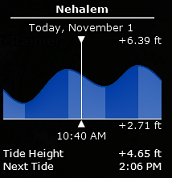
The maximum search distance for Tide Stations is 50NM. If there is no tide station within this distance, the NavData will display no information.
Note that it is possible to choose and fix the Tide Station being displayed in the NavData by selecting a Tide Station as a "Reference Station". Just right click on a Tide icon on the chart and select "Use as Reference Station". To release the reference station, you can right click on the NavData and select "Set Auto".
Tips: If you right click on the NavData you can select "Open Tide Graph", this will open the full Tide Graph for that station.
Current NavData
This NavData displays and updates in real time the nearest Current station information from your own ship position:
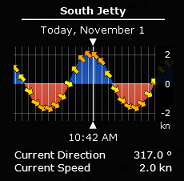
The maximum search distance for Current Stations is 4NM. If there is no current station within this distance, the NavData will display no information.
Note: It is not possible to fix a Tidal Current station. Currents are always automatically selected based on distance from own ship.
Tips: If you right click on the NavData you can select "Open Current Graph", this will open the full Current Graph for that station.
Weather NavData
The Weather NavData displays the weather forecast under the cursor using numerical value:
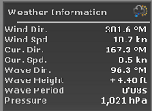
In the "Planning" WorkSpace, the time of the forecast is set by the timeline. In the "Navigation" WorkSpace, the time of the forecast is always set by computer current time.
You can right click on the NavData to add or remove specific weather data.
GPS Status NavData
The GPS Status NavData displays in large font "GPS OK" (in green), "Poor GPS" in yellow or "NO GPS" (flashing in red):
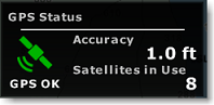
It also displays the GPS accuracy (based on HDOP) and the number of satellites that are used to compute the position fix.
Note: In order for the accuracy to be displayed in the NavData, the HDOP must be received in TimeZero (NMEA sentence GGA or GNS or GSA or PGN129029 or PGN129539). In order for Satellites in Use to be displayed, the NMEA0183 sentence GGA or GNS must be received. The GPS Poor quality indicator is a combination of HDOP and Satellites in Use (when HDOP > 4 or Satellite in use < 4).
Laylines NavData
The "Routing Module" needs to be unlocked to access this feature
The Laylines NavData displays the Port and Starboard layline optimum Course and Distance as well as Time To Go ("time to tack").
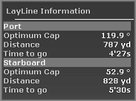
Please refer to the Laylines chapter for more information.
Trip Odometer NavData
The Trip Odometer NavData allows you to keep track of various trip statistics:
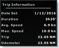
Note that all values (except Odometer) can be reset by right clicking and select "Reset". You can also enable or disable some information by right clicking on the NavData. Like in a car, the Odometer is never reset.
Tips: if you change computer or reset to factory default, the Odometer value will go back to 0. If you press and hold the CTRL key while right clicking on the NavData, a new item "Restore Odometer Value" will appear allowing you to enter any number.
Target Information NavData
The Target NavData displays detailed information about the selected target (AIS, ARPA or DSC). To select a target, just click on it. The target will become surrounded in yellow and the information will be displayed in the Target Information NavData:
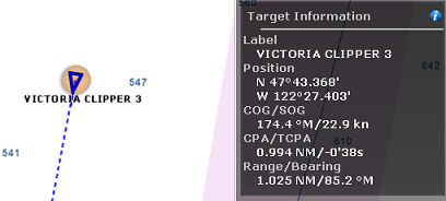
Note that once a target is selected (surrounded in yellow), you can select other objects (such as Marks or Boundaries) without affecting the target selection. Only selecting another target will change the target selection.
If you click on the "i" icon (blue icon on the top right), it will open the full target property window.
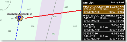
AIS and ARPA List NavData
The AIS and ARPA List NavData display a list of AIS or ARPA targets with basic information (to fit in the NavData):
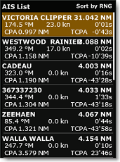
The list can be sorted by Range, CPA, TCPA or SOG when you right click on the NavData. It's also possible to choose the type of information displayed for each target, such as COG/SOG and/or CPA/TCPA. Additionally, you can filter the listed targets to show only those in your Favorite List or those currently engaged in fishing (when "AIS/ARPA Fishing Mode" is enabled and configured under the Targets Options).
The NavData panel automatically adjusts its size to fill the available space in its container. If all targets cannot be shown, you can scroll through the content of the AIS or ARPA NavData.
Clicking on an item in the list will center the chart on that target. Likewise, clicking on a target on the chart will highlight it in the list and scroll as needed to bring it into view:
When you assign a custom color to an AIS target, either by right-clicking on it and changing its color, or by adding it to your AIS Directory with a predefined color, the color of the target will appear at the edge of the NavData as shown below:
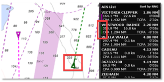
If you undock the NavData, a right click on it will allow you to set the size it occupies (to display 5, 10, 15, or 20 targets).
Alarm Zone NavData
Any Boundary Area can be set as an alarm zone by right clicking on the area and selecting "Own Ship Alarm". The Alarm Zone NavData is used to display the distance to the closest alarm boundary area. TimeZero will start by raising a notification when approaching the Alarm zone (you can set the distance of the "Own Ship Alarm Zone Warning" under the Alarms Options) then raise an alarm if the boat enters the alarm zone. The NavData will reflect the notification by displaying a yellow warning sign when the boat approaches the zone and red warning sign if the boat enters the alarm zone:
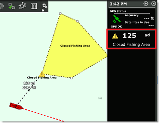
Note: When the distance to the alarm zone becomes smaller than the "Own Ship Alarm Zone Warning" value, a divider line is automatically displayed from the boat icon to the closest point of the alarm zone. The Alarm Zone NavData will also displayed any active TZ Maps Area warning or alarm (please refer to the Smart Zone chapter for more information).
Event NavData
The Event NavData allows you to quickly drop a mark under your boat with a specific icon and color. You can customize the icon and color of all the 11 events by clicking on the "i" icon available on the top right corner of the NavData:
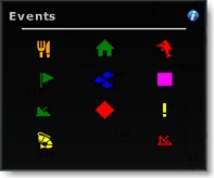
Note that events are extremely useful when fishing. You could preset specific icons and colors having a specific meaning (good pot, medium pot, bad pot) and simply use the cursor to immediately drop a mark containing the relevant information at your current position. Note that you can also use your keyboard by pressing the 0 to 9 numerical key and the Enter key (the Enter key corresponds to the bottom right event icon while the 0 key corresponds to the bottom left).
Quick Access NavData
The Quick Access NavData allows you to assign almost any function of TimeZero to a button that can be quickly activated:

When you add a Quick Access NavData, it will be empty by default. Simply click on it to open the configuration window:
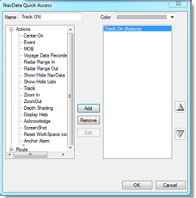
This window allows you to enter the name that will be displayed on the button, the color and the Action(s) you want to perform. You can perform virtually any action available in TimeZero. Note that you can combine (add) multiple action to the same button similar to macros! For example, you could configure a button to select 2D mode, turn OFF the Depth Shading and set the orientation mode to Head Up.
Sounder Control NavData
The Sounder Control NavData gives quick access the most sounder control: TX /STBY switch, mode button to switch between Manual/Fishing/Cruising and set the Gain HF & LF only for Manual mode:
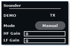
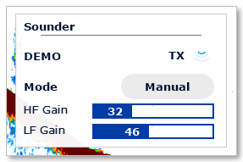
Note: Advanced user can also add Clutter control by right clicking the Sounder NavData.
Radar Control NavData
The Radar Control NavData gives quick access to the most used radar control: Gain, Sea (STC) & Rain (FTC):
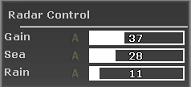
Tips: Click on the "A" to switch from Manual to Automatic mode for the selected parameter.
The Radar Control NavData can also display the "Tune" bar (read only). Simply right click on the NavData and add "Tune" to the NavData configuration.
Advanced Radar Control NavData
The Advanced Radar Control NavData gives quick access to the more advanced radar filters. Click on the filter value to cycle through the various mode:
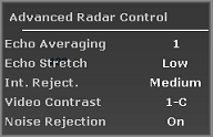
You can customize the NavData by right clicking on it.
Bottom Discrimination NavData
The Furuno Sounder Module and a Furuno BBDS1 or DFF1-UHD Ethernet Sounder are required to access this feature
This NavData displays real time bottom discrimination information when TimeZero is connected to a Furuno BBDS1 or DFF1-UHD Ethernet Sounder:
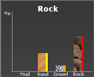
The four "bar graph" display the real time probability value of having either Mud/Sand/Gravel/Rock below the transducer. The colors located on the right side of each bar indicate the color of the corresponding type if the track color is set to variable according to bottom classification (from the Ship & Tracks Options).
At the top of this NavData, TimeZero displays the name of the highest probability bottom type.
Camera NavData
This NavData displays a video feed. If the camera has Pan, Tilt, and Zoom (PTZ) capabilities, a virtual joystick will appear when you roll your cursor over the NavData:
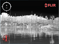
You can change the video source of the NavData by right clicking on it.
If the camera as additional features (such as the Flir M-Series), the right click contextual menu also gives access additional commands (Scan, Home, Scene, IR/Visible switch, etc...).
For more information, please refer to the Camera NavData Chapter.
Fuel Tank Level NavData
This NavData displays the Total Fuel Level:
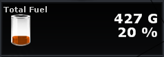
You can display individual tank level by right clicking on the NavData. The NickName of the Fuel Tank can be changed from the Initial Setup Options (under the "Fuel" Category).
Note: The Tank Level indicator can be used for other type of fluid than Fuel (for example grey water tank). If you are not using a specific tank for fuel, make sure to disable it from the Fuel computation in the Routes Options (uncheck "use fuel tank # in vessel computation")
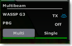
Multibeam NavData
The PBG module and (WASSP or DFF3D) Module are required to access this feature
The Multibeam NavData allows you transmit and standby the WASSP DRX (with WASSP Generation 3 system), enable or disable PBG and select the PBG depth source:
 or
or 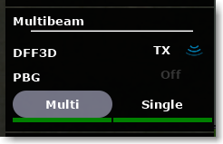
When selecting "Multi" the multibeam sounder (multiple points) will be used as PBG source. When selecting "Single" the regular depth (on point) will be used as PBG source. Typically, multibeam sounders are not able to track bottom in deep water. If you also have a traditional monobeam sounder connected to TimeZero, it may make sense to switch the PBG source to "Single" in deeper water.
A status indicator (green/red) is displayed under the "Multi" and "Single" selection to show you which type of data is currently available.
User Object Filters NavData
This NavData displays your user object filters using big buttons that are easy to toggle ON and OFF. For more information on how to create User Object filters, please refer to the Filters chapter.
SeaLevel IO NavData
This NavData allows you to control and monitor relays and input status from the SeaLevel Network IO 110E and 120E.
You can right click on this NavData to select which Input and Output you want to monitor/control (up to 4 inputs and 4 outputs). You can click on the "i" icon located on the top right to configure the SeaLevel hardware and rename the inputs and outputs. For more information, please refer to the SeaLevel Network IO Chapter.
Radio Direction Finder NavData
This NavData allows you to monitor the input of the RhoTheta Radio Direction Finder. It displays the information of the last bearing that was received together with channel number, frequency, and signal level:
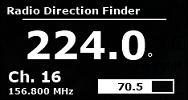
For more information, please refer to the Radio Direction Finder Chapter.
Simulation Mode NavData
This "NavData" is only available if TimeZero is running in simulation mode. When you start TimeZero, the message "simulation mode" appears at the top of the screen. For more information, please refer to the "Start mode" chapter.
Then add the "Simulation Mode" NavData, which lets you activate the simulation of your own ship by clicking on the arrows to increase and decrease speed and course, and move the boat icon as you wish on the chart:
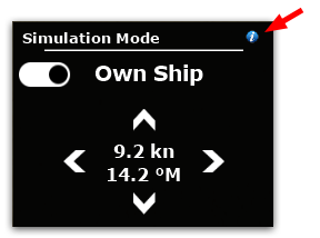
Note: Click on the "i" icon in the top right-hand corner of the NavData if you want to set the boat position manually using lat/lon.